

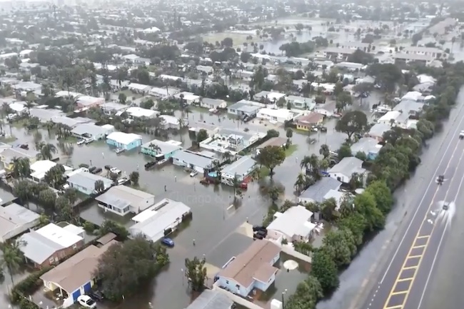
The relentless rain has led to dramatic flooding across Florida’s Atlantic shoreline, especially affecting Broward, Miami-Dade, and Brevard counties. In Broward County, areas like Fort Lauderdale and Hollywood saw over 15 inches of rainfall from Tuesday onward.
Recent measurements revealed Plantation received 16.4 inches, while Hollywood and Fort Lauderdale reported 13.8 and 12.2 inches, respectively. Fort Lauderdale-Hollywood International Airport registered nearly 17 inches within just two days, shattering the prior daily record of 1.8 inches from 1959.
Meanwhile, Melbourne has exceeded 17 inches this month alone, nearly doubling its historical November record, and Fort Lauderdale has surpassed previous totals for both November and autumn.
In Brevard County, rainfall totals ranged from 6 to 10 inches in areas like Rockledge and Merritt Island. An additional 3 to 8 inches might still come through Friday in some spots. The St. Johns River near Cocoa reached an unprecedented level of approximately 18.1 to 18.2 feet, surpassing the previous October 1953 record.
UPDATE: Drone video shows whole neighborhoods UNDER WATER in Satellite Beach, Florida, with people wading waist-deep past homes in South Patrick Shores as Brevard County's flooding spreads
> NWS Melbourne now has 4 active Flash Flood Warnings across Brevard, running into the… pic.twitter.com/McOCsHjxdh
— James Reichert (@_jamesreichert) November 19, 2026
The river is projected to crest near 18.4 feet later today, already affecting low-lying neighborhoods in Cocoa, Rockledge, and Palm Bay. As a result, schools were closed on Thursday in Broward, Miami-Dade, and Brevard counties, with some evacuations announced in Indian River and Volusia counties.
Palm Bay officials initiated both mandatory and voluntary evacuations for several neighborhoods, providing boat transport for stranded residents. Florida Fish and Wildlife Conservation Commission officers conducted over 70 rescues, saving residents and numerous pets from a flooded Hollywood apartment.
Numerous roads—including sections of Interstate 95, the Florida Turnpike, U.S. 1, and State Road 520—have been impacted, with vehicles either stalled or submerged. Flood watches remain in place for southeast Florida until Thursday evening and through Friday evening in much of east-central Florida.
The saturated ground conditions indicate that any further rainfall will lead to additional runoff. Meteorologist Cassie Wishard stated, “Any additional rainfall is going to become runoff.”
The heavy precipitation is attributed to a slow-moving low-pressure system exacerbated by El Niño, disrupting the usual dry season. Forecasters anticipate several more inches of rain through Friday, particularly impacting areas along the coast from Port St. Lucie northward.
While rain is expected to subside late Friday night into Saturday as the system shifts northward, river flooding along the St. Johns near Cocoa might persist for an extended duration, potentially leading to major flooding lasting into December, and minor flooding reaching into January 2027 in certain areas.
Fortunately, as of Thursday afternoon, no deaths or injuries were widely reported in relation to the current flooding, though earlier incidents this month resulted in fatalities.
